
Trails and Parks
Santee Cooper’s commitment to environmental stewardship is evident in the beautiful trails and parks we manage.
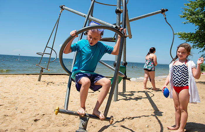
Overton Beach Park
Located on the banks of Lake Moultrie, this beach park offers a variety of outdoor fun including picnicking, swimming or just sunning on the beach. Overton Beach Park is open in the summer seven days a week from 10 a.m. to 6 p.m. beginning Memorial Day Weekend.
Overton Beach Park is located five miles north of Moncks Corner and has certified lifeguards on duty. Admission is $5 per person for ages 4 and up. A $100 family season pass allows admission for up to four people per vehicle. Picnic Shelters are available for rent from $100-$200. Annual passes to Old Santee Canal Park are not valid at Overton.
Phone: 843-761-8039
843-899-5200
Palmetto Trail
South Carolina's Palmetto Trail stretches from McClellanville in the Lowcountry to the Foothills Trail in the Upstate. It offers hikers the chance to experience the dozens of habitats and ecosystems throughout this great state.
Santee Cooper is proud to be part of this project through our development of the Lake Moultrie Passage.
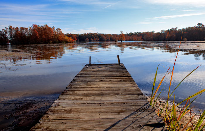


The Lake Moultrie Passage of the Palmetto Trail is approximately 26-miles long with an additional 6.2 miles of loop trails located in the Sandy Beach area. It begins at the U.S. Forest Service's Canal Recreation Area on U.S. Highway 52 near Santee Circle and ends adjacent to S.C. Highway 45 at the Diversion Canal near Santee Cooper's Cross Generating Station.
Parking is available near the trailhead on U.S. Highway 52 and adjacent to the Diversion Canal on the northwest end.
Vehicular access to the trail is also available at the Russellville Boat Landing at the end of Road S-8-204 and at the end of Sandy Beach Road near the Pineville Fire Tower on S.C. Highway 45.
Primitive campsites are available for hikers who want to extend their visit overnight. Campsites are supplied with fire rings. Campers are reminded to exercise care with campfires and carefully extinguish them before leaving the campsite.
Hikers should also be aware that snakes are indigenous to the area and should be avoided. Unless you are an expert in snake identification, assume they all are poisonous and steer clear. Hikers should carry insect repellent to ward off mosquitoes, especially in the summer months.
Much of the trail passes through SCDNR Wildlife Management Areas, and hunting is allowed from mid-September to Jan. 1. It is recommended that hikers wear brightly colored clothing while on the trail. The majority of this trail is on Santee Cooper's dikes with views of Lake Moultrie.
White-tailed deer, wild turkeys, mourning doves, alligators, redtail hawks, eagles and hundreds of other species call this area home. With luck, you'll catch a glimpse of many of them. The primary timber along the trail is a mixture of loblolly pine and hardwood forests.
These areas periodically undergo a carefully controlled burn process, which reduces scrub vegetation, opens the forest floor for better access, and improves wildlife habitat. The burn process is harmless to the animals that live there and increases their ability to thrive.
The lands around Lake Moultrie are generally flat and are usually only a couple of feet above the water table. As a result, heavy rains can cause the rain water to pond temporarily and may result in standing water in the woodlands. This ponding, however, is good for the proliferation of wildflowers and their seeds, and hikers can expect to see a variety of them blooming year round.
From the Canal Recreation Area, cross the canal on the wooden footbridge and proceed west on the woods road adjacent to the canal and toward the railroad tracks. Cross the tracks and continue to the top of the Pinopolis East Dike (0.5 miles). Bikers can gain access to the top of the dike by following south along its base approximately 0.4 miles to an access ramp.
Once atop the dike, proceed north until the dike ends at Secondary Road 42 (3.5 miles).
The trail leaves the dike and proceeds west along Secondary Road 42 to Butter Road (Secondary Road 470). Turn north on Butter Road and go approximately 0.6 miles and turn east on Barn Road. Then go 0.5 miles and turn north on Pauline Drive to General Moultrie Road. Turn east and follow General Moultrie Road to return to Santee Cooper's dike system (2.2 miles total).
This temporary section on paved roads runs through a mixed residential and commercial area. Once back on the dike, proceed north along the top for approximately 1.8 miles to the sign for camping. A primitive camping site is available at this location approximately 0.3 miles inside the dike.
From the camping sign on the dike, the main trail follows the dike north to the Rediversion Canal (3.9 miles). Hikers should follow the gravel road adjacent to the Rediversion Canal northeast to the paved road (Secondary Road 35) and cross the bridge over the Rediversion Canal. Then follow the gravel road southwest along the Rediversion Canal back to the dike (2.0 miles).
Continue to follow the dike west for approximately 3.6 miles to the sign for camping. A primitive campsite is available 0.2 miles inside the dike at this location. Several loop trails are also available in this area from March 2 to Nov. 15.
These loop trails total 6.2 miles and provide the trail user with views of the lake, an eagle's nest, and the Sandy Beach Waterfowl Management Area. A second primitive campsite is available on the shores of Lake Moultrie at Sandy Beach when these loop trails are open. The loop trails are closed from Nov. 16 to March 1 to provide undisturbed quality habitat for the area's waterfowl population.
The main trail continues from the camping sign northwest along the dike until the dike ends at the remains of the historic Santee Canal (2.6 miles). Hikers may cross the abandoned canal on the railroad trestle, then proceed southeast on the woods road, which parallels the old canal for approximately 0.4 miles.
Turn southwest on the woods road, which leads to a wooded trail with boardwalks. Continue on the trail and cross Quattlebaum's Canal on a wooden footbridge. Then follow the wooded trail to the railroad tracks (1.4 miles). Cross the tracks and follow the woods road southwest until it ends at Secondary Road 708 (1.3 miles).
Turn northwest along Secondary Road 708 for approximately 0.4 miles to another woods road. Proceed southwest along this road for about 0.3 miles to a primitive campsite. From this campsite continue southwest on the woods road to the Diversion Canal. Turn northwest on the woods road that parallels the Diversion Canal up to the parking area (1.5 miles).
- Be considerate of fellow trail users.
- Keep the trail clean. Do not litter.
- Obey all state laws, rules and regulations relating to personal conduct and the protection of private and public property.
- Respect private property. Do not trespass.
- Camp only in designated areas and limit camping to a period not to exceed two weeks. Leave campsites cleaner than you found them. Contain campfires and do not leave them unattended.
- Avoid destroying, defacing or removing any natural feature or plant, including driving nails into green trees.
- Do not discharge firearms or fireworks.
- Stay on designated trails. Don't take shortcuts or create new trails.
- Mountain bikers should ride at a safe speed and avoid maneuvers that damage the trail.
- Avoid muddy trails. Save them for future trips when they are dry.
- Mountain bikers should pass hikers with care. Hikers have the right of way on the trail.
- Avoid deliberately disturbing wildlife.
- Bury human waste 6-8 inches deep at least 200 feet from any water source.
- Dogs must be on a leash at all times.
- Horses and motorized vehicles are prohibited.
For more Lake Moultrie Passage information, contact:
Supervisor - Forestry and Undeveloped Lands
Santee Cooper Land Division
1 Riverwood Dr.
Moncks Corner, SC 29461
843-761-8000
The South Carolina Trails Program provides more information about the Palmetto Trail and other trails in the state.
Trailhead of the Lake Moultrie Passage
From I-26, take U.S. Hwy. 52 or U.S. Hwy 17A into Moncks Corner. Take Hwy. 52 North out of Moncks Corner. You will see signage at the Canal Recreation Area on the left, 3.6 miles from the split of Hwy. 52 and 17A. From I-95, take S.C. Hwy. 6 to Moncks Corner, and follow the directions above.
Old Santee Canal Park
Old Santee Canal Park is a 195-acre park commemorating the area's rich history and habitat. Attractions include the Stony Landing House, built in 1843, and four miles of boardwalks and trails that meander through the quiet backwaters of Biggin Creek and its surrounding swamp. The park's centerpiece is its Interpretive Center that chronicles the area's history as far back as 4000 B.C. The Berkeley County Museum and Heritage Center is also located within the park's gates.
Park Website